
ファイル:Venus - 3D Perspective View of Maat Mons.jpg
このプレビューのサイズ: 800 × 600 ピクセル。 その他の解像度: 320 × 240 ピクセル | 640 × 480 ピクセル | 1,024 × 768 ピクセル | 1,280 × 960 ピクセル | 2,560 × 1,920 ピクセル | 4,000 × 3,000 ピクセル。
元のファイル (4,000 × 3,000 ピクセル、ファイルサイズ: 1.09メガバイト、MIME タイプ: image/jpeg)
| 解説 |
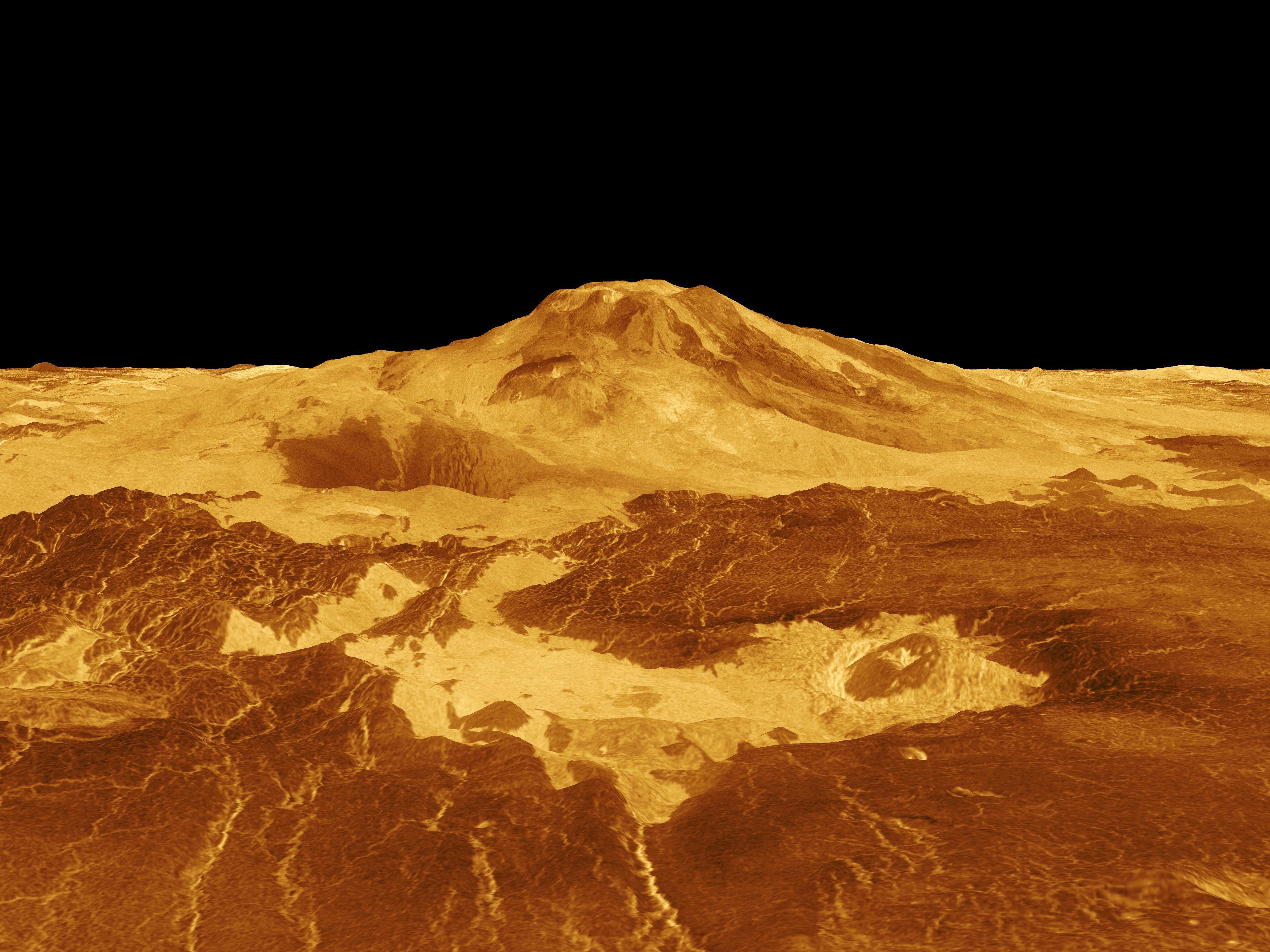
English: Maat Mons is displayed in this computer generated three-dimensional perspective of the surface of Venus. The viewpoint is located 634 kilometers (393 miles) north of Maat Mons at an elevation of 3 kilometers (2 miles) above the terrain. Lava flows extend for hundreds of kilometers across the fractured plains shown in the foreground, to the base of Maat Mons. The view is to the south with the volcano Maat Mons appearing at the center of the image on the horizon and rising to almost 5 kilometers (3 miles) above the surrounding terrain. Maat Mons is located at approximately 0.9 degrees north latitude, 194.5 degrees east longitude with a peak that ascends to 8 kilometers (5 miles) above the mean surface. Maat Mons is named for an Egyptian Goddess of truth and justice. Magellan synthetic aperture radar data is combined with radar altimetry to develop a three-dimensional map of the surface. The vertical scale in this perspective has been exaggerated 10 times. Rays cast in a computer intersect the surface to create a three-dimensional perspective view. Simulated color and a digital elevation map developed by the U.S. Geological Survey are used to enhance small-scale structure. The simulated hues are based on color images recorded by the Soviet Venera 13 and 14 spacecraft. The image was produced by the Solar System Visualization project and the Magellan Science team at the JPL Multimission Image Processing Laboratory and is a single frame from a video released at the April 22, 1992 news conference. Українська: Панорама Венери. Потоки лави на 400-км ділянці поверхні Венери |
|||||
| 日付 | ||||||
| 原典 | http://photojournal.jpl.nasa.gov/catalog/PIA00106 | |||||
| 作者 |
|
|||||
| 許可 (ファイルの再利用) |
|

ファイルの履歴
過去の版のファイルを表示するには、その版の日時をクリックしてください。
| 日付と時刻 | サムネイル | 寸法 | 利用者 | コメント | |
|---|---|---|---|---|---|
| 現在の版 | 2009年2月14日 (土) 10:34 | | 4,000 × 3,000 (1.09メガバイト) | Complex01 | {{Information |Description={{en|1=Maat Mons is displayed in this computer generated three-dimensional perspective of the surface of Venus. The viewpoint is located 634 kilometers (393 miles) north of Maat Mons at an elevation of 3 kilometers (2 miles) abo |
リンク
この画像にリンクしているページの一覧:
グローバルなファイル使用状況
以下に挙げる他のウィキがこの画像を使っています:
- ar.wikipedia.org での使用状況
- ca.wikipedia.org での使用状況
- cy.wikipedia.org での使用状況
- en.wikipedia.org での使用状況
- es.wikipedia.org での使用状況
- eu.wikipedia.org での使用状況
- fr.wikipedia.org での使用状況
- gl.wikipedia.org での使用状況
- he.wikipedia.org での使用状況
- it.wikipedia.org での使用状況
- ja.wikipedia.org での使用状況
- mk.wikipedia.org での使用状況
- nl.wikipedia.org での使用状況
- pl.wikipedia.org での使用状況
- th.wikipedia.org での使用状況
- tr.wikipedia.org での使用状況
- uk.wikipedia.org での使用状況
- www.wikidata.org での使用状況
- zh.wikipedia.org での使用状況