ファイル:Transasia trade routes 1stC CE gr2.png

ページのコンテンツが他言語でサポートされていません。
出典: フリー教科書『ウィキブックス(Wikibooks)』

Transasia_trade_routes_1stC_CE_gr2.png(800 × 480 ピクセル、ファイルサイズ: 218キロバイト、MIME タイプ: image/png)

このファイルはウィキメディア・コモンズから来ており、他のプロジェクトで使用されている可能性があります。 ウィキメディア・コモンズでのファイル解説ページにある説明を以下に示します。

この地図画像は、ベクターイメージである SVG ファイルとして再作成されるべきです。これにはいくつかの利点があります。詳しくはCommons:Media for cleanupを参照してください。この画像の SVG 形式がすでに利用可能である場合は、アップロードしてください。アップロード後、この画像にあるこのテンプレートを{{Vector version available|新しい画像ファイル名.svg}}テンプレートで置き換えてください。

概要

このファイルのベクター画像 (SVG) が利用できます。 使う目的に対し、元画像よりもSVGがより優れている場合、SVG画像を使用して下さい。 (理由: coloured version, white version still needs to be created)

File:Transasia trade routes 1stC CE gr2.png → File:Silk Road in the I century AD - ru.svg

ベクターグラフィックスの詳細については、コモンズのSVG変換を参照ください。
SVGのMediaWikiのサポートに関する情報もあります。

他言語
Alemannisch  Bahasa Indonesia  Bahasa Melayu  British English  català  čeština  dansk  Deutsch  eesti  English  español  Esperanto  euskara  français  Frysk  galego  hrvatski  Ido  italiano  lietuvių  magyar  Nederlands  norsk bokmål  norsk nynorsk  occitan  Plattdüütsch  polski  português  português do Brasil  română  Scots  sicilianu  slovenčina  slovenščina  suomi  svenska  Tiếng Việt  Türkçe  vèneto  Ελληνικά  беларуская (тарашкевіца)  български  македонски  нохчийн  русский  српски / srpski  татарча/tatarça  українська  ქართული  հայերեն  বাংলা  தமிழ்  മലയാളം  ไทย  한국어  日本語  简体中文  繁體中文  עברית  العربية  فارسی  +/−
新しいSVG画像

ライセンス

この作品の著作権者である私は、この作品を以下のライセンスで提供します。
GNU head この文書は、フリーソフトウェア財団発行のGNUフリー文書利用許諾書 (GNU Free Documentation License) 1.2またはそれ以降のバージョンの規約に基づき、複製や再配布、改変が許可されます。不可変更部分、表紙、背表紙はありません。このライセンスの複製は、GNUフリー文書利用許諾書という章に含まれています。
w:ja:クリエイティブ・コモンズ
表示 継承
このファイルはクリエイティブ・コモンズ 表示-継承 3.0 非移植ライセンスのもとに利用を許諾されています。
あなたは以下の条件に従う場合に限り、自由に
  • 共有 – 本作品を複製、頒布、展示、実演できます。
  • 再構成 – 二次的著作物を作成できます。
あなたの従うべき条件は以下の通りです。
  • 表示 – あなたは適切なクレジットを表示し、ライセンスへのリンクを提供し、変更があったらその旨を示さなければなりません。これらは合理的であればどのような方法で行っても構いませんが、許諾者があなたやあなたの利用行為を支持していると示唆するような方法は除きます。
  • 継承 – もしあなたがこの作品をリミックスしたり、改変したり、加工した場合には、あなたはあなたの貢献部分を元の作品とこれと同一または互換性があるライセンスの下に頒布しなければなりません。
このライセンスのテンプレートは、GFDLのライセンス・アップデートによりこのファイルに追加されたものです。
あなたは上記のライセンスから、どれか一つ以上を選択できます。

Map information

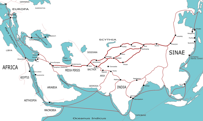
This map indicates trading routes used around the 1st century CE centred on the Silk Road. The routes remain largely valid for the period 520 BCE to 500 CE.

Geographical labels for regions are adapted from the Geography of Ptolemy (c. 150 CE), some trading centre names date from later (c. 400 CE). Relying on Ptolemy's names is wrong but neutral.

The following contemporary trading centres (or possible trading centres) are not marked:

Red Sea - Myos Hormos, Berenica, Ptolemais Theron, Adulis, Muza, Ocalis, Aualites, Malao.

Arabia - [South] Saue, Sana, Saphar, Eudaemon Arabia, Cane, Mosyllon, Moscha

Persian Gulf - Asabon, Charax, Gerra, Ommana, Apologos

Persia - Persepolis, Alexandria Areion, Kandahar

Africa - [East Africa/Kush/Axum] Coloe, Axum, Akhmim, Panopolis, Aromaton Emporion, Opone, Sarapion, Dongola. [Mediterranean] Cyrene, Leptis Magna, Carthage, Caesarea, [Beyond map] [East Africa] Juba, Maji, Sennar, [Trans-Saharan] Sijilmassa, Tamanrasset, Murzuk, Tingis.

Europe - Gades (Cadiz), Augusta Treverorum (Trier), Aquileia, Ostia, Athens

India - [Arabian Sea] Horaia, Barbaricum, Barake, Astakapra, Suppara, Kalliena, Semylla, Mandagora, Palaepatmae, Melizeigara, Erannoboas, Byzantion, Naura, Tymdis, [Central] Paethana, Tagara, [South] Muziris, Nelcynda, Bacare, Balita, Colchi, Palaesimundu, [East] Argaru, Poduca, Sopatma.

Silk Road - Ecbatana, Yarkand, Jiaohei, Kitai, Kaifeng. (Note - both summer and winter routes around the Takla Makan are shown)

China - Chengdu, Kunming, Cattgara

South East Asia - Trang, Thaton

The routes between most of these unindicated sites are not marked, notably the extensive European/Roman routes and the other routes in Persia beyond the Silk Road. Another route not indicated is the Scythian route running from China to the Black Sea. The large number not marked on India are the minor sites listed in the Periplus of the Erythraean Sea.

Origins of trade goods

China - silk, clothing, lacquerware, spices

Indo-China - spices, ivory, timber, pearls

Northern India - precious stones, ivory, tortoiseshell, incense, spices, cloth, timber

Southern India - ivory, tortoiseshell, spices, precious stones, cloth, timber

Arabia - spices, slaves, precious stones

East Africa - gold, ivory, exotic animals, slaves, incense

Trans-Sahara - ivory, gold, slaves

North Africa - grain,

Southern Europe - olive oil, wine, glassware, coinage

Western Europe - silver, tin

Northern Europe - slaves, amber,

Asia Minor - silver, precious stones, timber, wine

Image editing

The source for this PNG was an SVG. This file is available.


from en wp

(del) (cur) 23:55, 30 March 2006 . . TwoOneTwo (Talk) . . 1223x794 (374899 bytes)


  • (cur) (last) 00:12, 31 March 2006 82.24.208.109 (→Map information)
  • (cur) (last) 00:00, 31 March 2006 TwoOneTwo m
  • (cur) (last) 23:55, 30 March 2006 TwoOneTwo
注釈
InfoField
この画像には注釈がついています: コモンズで注釈を見る

キャプション

このファイルの内容を1行で記述してください

このファイルに描写されている項目

題材

9c242d0941efe86f2a49bc8d9bcd58e068032287

223,663 バイト

480 ピクセル

800 ピクセル

ファイルの履歴

過去の版のファイルを表示するには、その版の日時をクリックしてください。

日付と時刻サムネイル寸法利用者コメント
現在の版2021年2月18日 (木) 01:432021年2月18日 (木) 01:43時点における版のサムネイル800 × 480 (218キロバイト)MrPersonHumanGuyPurging the page didn't work, so I'm trying this again a third time
2021年2月18日 (木) 00:522021年2月18日 (木) 00:52時点における版のサムネイル800 × 480 (202キロバイト)MrPersonHumanGuyWell that didn't work, trying again (I'm wondering why it's only showing the previous version)
2021年2月18日 (木) 00:452021年2月18日 (木) 00:45時点における版のサムネイル800 × 480 (182キロバイト)MrPersonHumanGuyfixed Macrobia
2013年1月8日 (火) 23:032013年1月8日 (火) 23:03時点における版のサムネイル800 × 480 (182キロバイト)RunehelmetRegion added
2012年6月4日 (月) 10:322012年6月4日 (月) 10:32時点における版のサムネイル1,194 × 716 (264キロバイト)Mayhaymateoptimized
2006年6月3日 (土) 03:212006年6月3日 (土) 03:21時点における版のサムネイル1,194 × 716 (308キロバイト)Stevertigo (usurped)cropped version - needs more work - requested the SVG from original creator.
2006年4月20日 (木) 14:562006年4月20日 (木) 14:56時点における版のサムネイル1,223 × 794 (366キロバイト)Shizhao== Licensing == {{GFDL-self}} == Map information == This map indicates trading routes used around the 1st century CE centred on the Silk Road. The routes remain largely valid for the period 500 BCE to 500 CE. Geographical labels for regions are adap

この画像にリンクしているページの一覧:

グローバルなファイル使用状況

以下に挙げる他のウィキがこの画像を使っています:

このファイルのグローバル使用状況を表示する。

メタデータ