
ファイル:Mars topography (MOLA dataset) HiRes.jpg

このプレビューのサイズ: 800 × 457 ピクセル。 その他の解像度: 320 × 183 ピクセル | 640 × 366 ピクセル | 1,024 × 585 ピクセル | 1,280 × 732 ピクセル | 2,560 × 1,463 ピクセル | 12,140 × 6,940 ピクセル。
元のファイル (12,140 × 6,940 ピクセル、ファイルサイズ: 17.2メガバイト、MIME タイプ: image/jpeg)
| 警告 | この画像を最大解像度で表示する際に、一部のブラウザで問題が起きることがあります。この画像は画素数が非常に大きいため、正しく読み込まれなかったりブラウザがフリーズしたりする可能性があります。 |
|---|
概要
| 解説 |
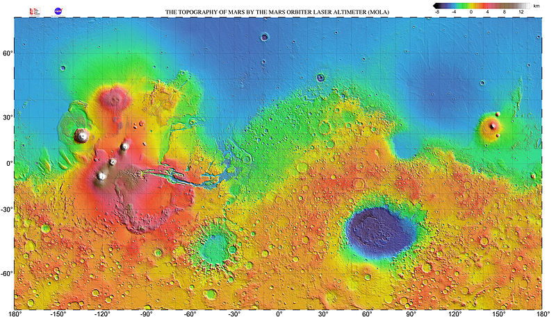
English: Very high resolution topographic shaded relief map of Mars. The map has a resolution 0.125° (300 dots per inch) and is shown as a mercator projection to latitude 70° north and south. The original NASA image has been modified by increasing the font size of the map grid and elevation key labels. |
| 日付 | |
| 原典 | http://mola.gsfc.nasa.gov/images.html |
| 作者 | NASA |
| その他のバージョン |

|
_with_poles_HiRes.jpg)
_HiRes.jpg)
ライセンス
| このファイルはアメリカ航空宇宙局(NASA)によって作成されたものです。NASAの著作権の方針では、特記事項が無い場合、NASAの資料はパブリックドメインとなります。 (詳しくはTemplate:PD-USGov、NASAの著作権の方針について(英語)又はジェット推進研究所(JPL)の画像使用に関するガイドライン(英語)をご覧ください。) |
||
 |
注意事項:
|
| 注釈 | この画像には注釈がついています: コモンズで注釈を見る |
ファイルの履歴
過去の版のファイルを表示するには、その版の日時をクリックしてください。
| 日付と時刻 | サムネイル | 寸法 | 利用者 | コメント | |
|---|---|---|---|---|---|
| 現在の版 | 2014年5月23日 (金) 07:35 | | 12,140 × 6,940 (17.2メガバイト) | WolfmanSF | further increase font size for map grid & color key labels |
| 2014年5月19日 (月) 07:37 |  | 12,032 × 6,912 (17.88メガバイト) | WolfmanSF | Increase font size on map grid labels | |
| 2009年3月11日 (水) 03:44 |  | 12,032 × 6,912 (17.6メガバイト) | Masur | {{Information |Description={{en|1=Very high resolution topographic shaded relief map of Mars. The map has a resolution 0.125° (300 dots per inch) and is shown as a mercator projection to latitude 70° north and south.}} |Source=http://mola.gsfc.nasa.gov/ |
リンク
この画像にリンクしているページの一覧:
グローバルなファイル使用状況
以下に挙げる他のウィキがこの画像を使っています:
- fr.wikipedia.org での使用状況
- ru.wikipedia.org での使用状況
- uk.wikipedia.org での使用状況
- zh.wikipedia.org での使用状況
_HiRes.jpg)